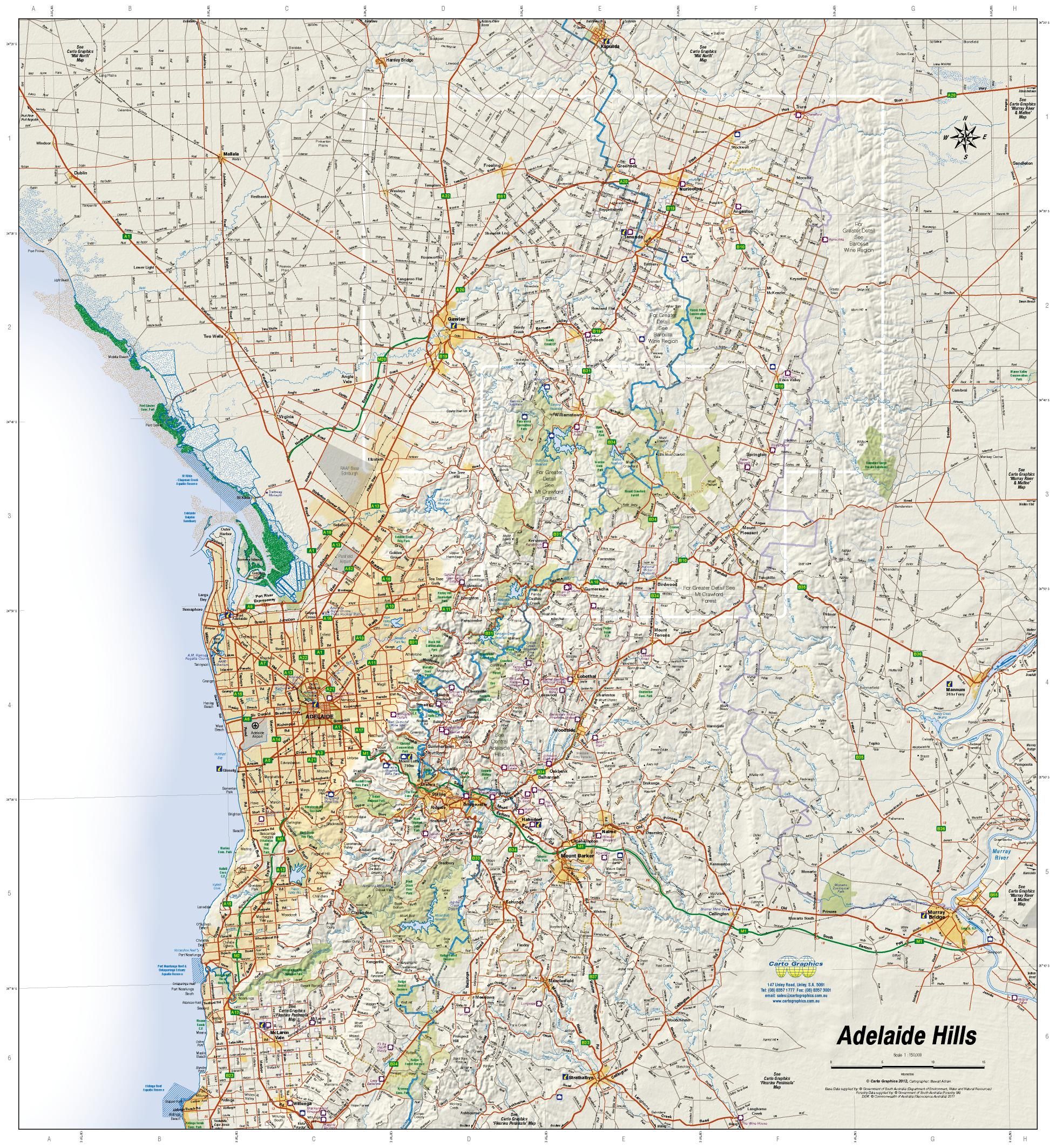
Adelaide Hills & Barossa Carto Graphics Map
Detailed Topographic & Cellar Door Map | Trails, Parks & Wineries
Scale: 1:150,000 (main) | Size: 1000 mm x 700 mm | Folded or Laminated
Explore the scenic backroads, historic towns, and world-class wine regions of South Australia with the Adelaide Hills & Barossa Map by Carto Graphics. Designed for both recreational explorers and serious walkers or cyclists, this high-resolution topographic map combines regional touring detail with localised insets—perfect for planning day hikes, cellar door adventures, or scenic drives.
📍 Key Features
| ✔️ Feature | 💬 Description |
|---|---|
| 🛣️ Detailed Road Mapping | All named roads clearly marked—sealed and unsealed |
| 🍷 Cellar Doors & Wineries | Showcased across the Barossa & Adelaide Hills regions |
| 🥾 Long-Distance Walking Trails | Includes Heysen Trail, Kidman Trail, Lavender Federation Trail, and Mawson Trail |
| 🏞️ Parks & Forests | National parks, state forests, and conservation areas clearly shown |
| 🗻 Hill Shading & Relief | Topographic hill shading for elevation clarity |
| 🗺️ Inset Maps | - 1:50,000 scale: Crafers to Hahndorf (central Adelaide Hills) |
| - 1:50,000 scale: Mount Crawford Forest | |
| - 1:75,000 scale: Barossa Wine Region |
📌 Coverage Area
-
North: Kapunda
-
South: Strathalbyn
-
West: Adelaide city fringe
-
East: Murray Bridge
-
Includes popular areas such as:
-
Hahndorf
-
Stirling
-
Mount Barker
-
Angaston
-
Tanunda
-
Lyndoch
-
Cudlee Creek
-
Birdwood
-
Mount Pleasant
-
Eden Valley
-
🧭 Ideal For:
-
🍇 Wine tourists and weekend travellers
-
🥾 Bushwalkers and hikers tackling long-distance trails
-
🚲 Cyclists exploring the Mawson Trail and local circuits
-
🧑🌾 Locals, small producers, and rural property owners
-
🧑🏫 Educators and students studying SA’s geography and terrain
-
🚙 Caravaners and campers looking for off-the-beaten-path stops
📐 Product Specifications
| Specification | Detail |
|---|---|
| Publisher | Carto Graphics |
| Scale | 1:150,000 (main) |
| Inset Scales | 1:50,000 (Mount Crawford, Crafers to Hahndorf), 1:75,000 (Barossa) |
| Size (Flat) | 1000 mm x 700 mm |
| Format | Folded paper map (optional lamination available) |
| Material (base) | High-quality full-colour paper |
| Made in | Australia |
🔒 Optional Upgrade: Laminated Version
Choose the laminated version of this map for added durability and reusability:
-
🧽 Wipe-clean surface – draw routes or mark points with whiteboard markers
-
💪 Tear-resistant & waterproof – ideal for fieldwork or outdoor use
-
🧴 80-micron gloss encapsulation – protects both sides of the map
-
✅ Fold lines may still be faintly visible (due to flattening of folded map prior to lamination)
🛒 Add to Cart – Discover the Heart of South Australian Wine & Wilderness
From vineyard trails to eucalyptus forests, the Adelaide Hills & Barossa Map brings South Australia's most beloved regions into sharp focus. Whether you're sipping wine in Seppeltsfield or hiking the ranges beyond Birdwood, this map is your trusted companion.
📦 Available folded or laminated – select the version that suits your journey.
Original: $11.95
-70%$11.95
$3.58

Description
Detailed Topographic & Cellar Door Map | Trails, Parks & Wineries
Scale: 1:150,000 (main) | Size: 1000 mm x 700 mm | Folded or Laminated
Explore the scenic backroads, historic towns, and world-class wine regions of South Australia with the Adelaide Hills & Barossa Map by Carto Graphics. Designed for both recreational explorers and serious walkers or cyclists, this high-resolution topographic map combines regional touring detail with localised insets—perfect for planning day hikes, cellar door adventures, or scenic drives.
📍 Key Features
| ✔️ Feature | 💬 Description |
|---|---|
| 🛣️ Detailed Road Mapping | All named roads clearly marked—sealed and unsealed |
| 🍷 Cellar Doors & Wineries | Showcased across the Barossa & Adelaide Hills regions |
| 🥾 Long-Distance Walking Trails | Includes Heysen Trail, Kidman Trail, Lavender Federation Trail, and Mawson Trail |
| 🏞️ Parks & Forests | National parks, state forests, and conservation areas clearly shown |
| 🗻 Hill Shading & Relief | Topographic hill shading for elevation clarity |
| 🗺️ Inset Maps | - 1:50,000 scale: Crafers to Hahndorf (central Adelaide Hills) |
| - 1:50,000 scale: Mount Crawford Forest | |
| - 1:75,000 scale: Barossa Wine Region |
📌 Coverage Area
-
North: Kapunda
-
South: Strathalbyn
-
West: Adelaide city fringe
-
East: Murray Bridge
-
Includes popular areas such as:
-
Hahndorf
-
Stirling
-
Mount Barker
-
Angaston
-
Tanunda
-
Lyndoch
-
Cudlee Creek
-
Birdwood
-
Mount Pleasant
-
Eden Valley
-
🧭 Ideal For:
-
🍇 Wine tourists and weekend travellers
-
🥾 Bushwalkers and hikers tackling long-distance trails
-
🚲 Cyclists exploring the Mawson Trail and local circuits
-
🧑🌾 Locals, small producers, and rural property owners
-
🧑🏫 Educators and students studying SA’s geography and terrain
-
🚙 Caravaners and campers looking for off-the-beaten-path stops
📐 Product Specifications
| Specification | Detail |
|---|---|
| Publisher | Carto Graphics |
| Scale | 1:150,000 (main) |
| Inset Scales | 1:50,000 (Mount Crawford, Crafers to Hahndorf), 1:75,000 (Barossa) |
| Size (Flat) | 1000 mm x 700 mm |
| Format | Folded paper map (optional lamination available) |
| Material (base) | High-quality full-colour paper |
| Made in | Australia |
🔒 Optional Upgrade: Laminated Version
Choose the laminated version of this map for added durability and reusability:
-
🧽 Wipe-clean surface – draw routes or mark points with whiteboard markers
-
💪 Tear-resistant & waterproof – ideal for fieldwork or outdoor use
-
🧴 80-micron gloss encapsulation – protects both sides of the map
-
✅ Fold lines may still be faintly visible (due to flattening of folded map prior to lamination)
🛒 Add to Cart – Discover the Heart of South Australian Wine & Wilderness
From vineyard trails to eucalyptus forests, the Adelaide Hills & Barossa Map brings South Australia's most beloved regions into sharp focus. Whether you're sipping wine in Seppeltsfield or hiking the ranges beyond Birdwood, this map is your trusted companion.
📦 Available folded or laminated – select the version that suits your journey.