Chile South & Patagonia ITMB Map
Scale: 1:1,750,000 & 1:2,000,000 | Size: 690mm x 1000mm
Includes Easter Island, Robinson Crusoe Island & Ushuaia Insets
Explore the Southern Frontier – From Los Angeles to Cape Horn
🏔️ A Deep Dive into South America’s Wildest Landscapes
For explorers of remote terrain, nature lovers, and cultural wanderers, this Chile South & Patagonia Map by ITMB (International Travel Maps) is your go-to navigation tool for discovering the dramatic southern edge of South America.
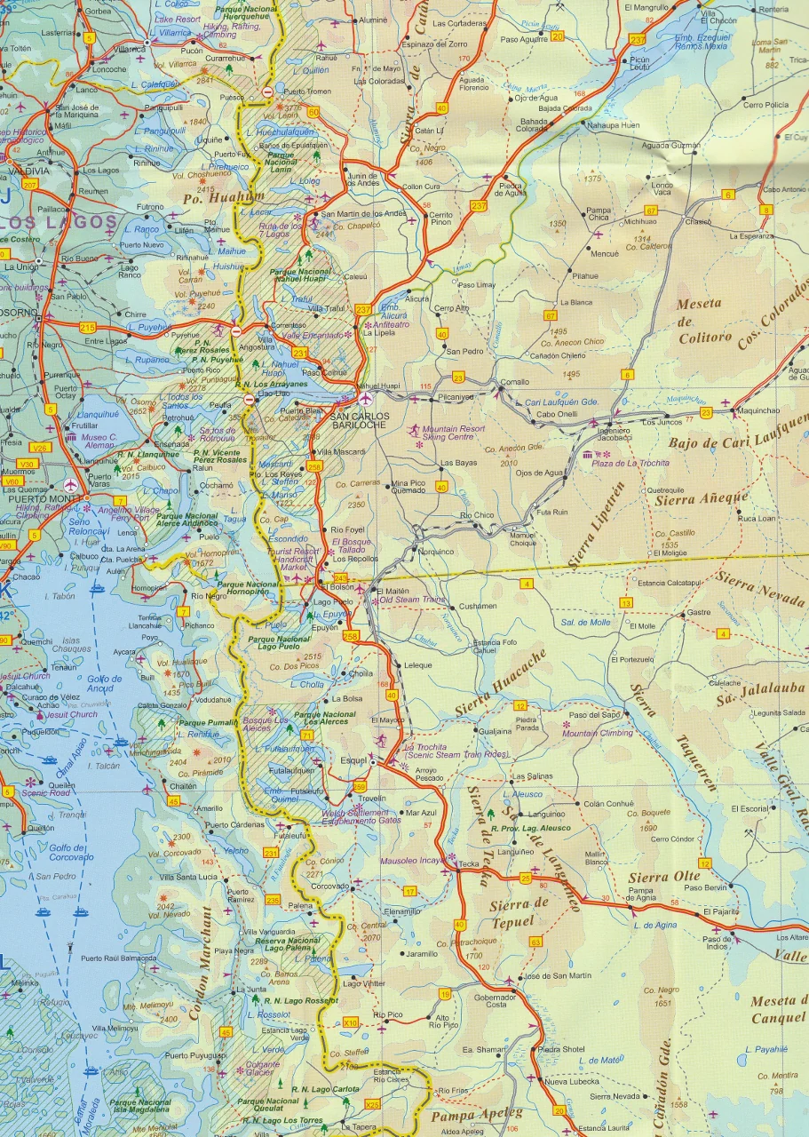
Covering the ever-evolving Chilean Austral region, the mystical expanses of Patagonia, and even the windswept reaches of Tierra del Fuego, this beautifully illustrated map captures one of the planet’s most striking, untamed regions in exceptional detail.
This is not just a map of roads — it’s a gateway to fjords, glaciers, islands, and forgotten outposts.
📍 What’s on the Map?
🧭 Side 1: Southern Chile in Detail – Scale 1:1,750,000
-
🇨🇱 Covers Chile south of Los Ángeles (yes, there’s one in Chile!)
-
🧭 Two vertical strip maps guide you from central Chile all the way to Cape Horn
-
🏞️ Includes national parks, lakes, fjords, ferry routes, and key tourist sites
-
🗺️ Insets Include:
-
🏝️ Easter Island (Rapa Nui) – main tourist areas clearly marked
-
🌴 Robinson Crusoe Island – the real-life inspiration for Daniel Defoe’s novel
-
❄️ Ushuaia – the southernmost city in the world, gateway to Antarctica
-
🌎 Side 2: Full Regional Overview – Scale 1:2,000,000
-
🌍 All of Chile from Temuco south, and Argentina from Neuquén and Bahía Blanca south
-
🏔️ Full view of Patagonia’s geographic span — glaciers, pampas, and national reserves
-
🇫🇰 Includes The Falkland Islands, accurately positioned in the South Atlantic
💧 Waterproof or Laminated – You Choose
🌦️ Default format is printed on waterproof, tear-resistant synthetic paper — ideal for adventure travel.
🛠️ Laminated version adds protection and versatility:
-
✅ Write-on / wipe-off surface – Perfect for plotting expeditions and routes
-
✅ Map Dot compatible – Highlight your journey stops or planned visits
-
✅ Tear-proof and stain-resistant – Ideal for offices, schools, fieldwork, or planning spaces
-
🛠️ Note: Laminated editions are created from professionally flattened folded maps; some original crease lines may remain faintly visible
🧳 Who This Map Is For
-
🎒 Overland Travellers & Backpackers – Navigate from volcanic highlands to icy fjords
-
🛳️ Cruise Planners & Antarctic Voyagers – Track port routes and the southern sea
-
🗺️ Expedition Guides & Tour Operators – Use as a reference for journey logistics
-
📚 Teachers & Students – Excellent educational tool for geography or history of South America
-
🏕️ Map Collectors & Outdoor Enthusiasts – A rare and beautiful reference for an extraordinary part of the world
📏 Product Specifications
| Feature | Details |
|---|---|
| Map Title | Chile South & Patagonia Travel Map |
| Publisher | ITMB – International Travel Maps |
| Scale | 1:1,750,000 (Chile South) |
| Map Size | 690mm (W) x 1000mm (H) |
| Format | Folded waterproof paper or laminated wall map |
| Insets | Easter Island, Robinson Crusoe Island, Ushuaia |
| Material (Laminated) | 80-micron gloss laminate, writeable with whiteboard markers |
| Printed In | Canada 🇨🇦 |
🛒 Add to Cart Today
From navigating Chilean fjords to tracing the windswept steppes of Patagonia, this ITMB map offers both fine detail and rugged durability for anyone venturing south of the ordinary.
Choose your format and add to cart now — and let the great southern journey begin.
Original: $24.95
-70%$24.95
$7.48


Description
Scale: 1:1,750,000 & 1:2,000,000 | Size: 690mm x 1000mm
Includes Easter Island, Robinson Crusoe Island & Ushuaia Insets
Explore the Southern Frontier – From Los Angeles to Cape Horn
🏔️ A Deep Dive into South America’s Wildest Landscapes
For explorers of remote terrain, nature lovers, and cultural wanderers, this Chile South & Patagonia Map by ITMB (International Travel Maps) is your go-to navigation tool for discovering the dramatic southern edge of South America.
Covering the ever-evolving Chilean Austral region, the mystical expanses of Patagonia, and even the windswept reaches of Tierra del Fuego, this beautifully illustrated map captures one of the planet’s most striking, untamed regions in exceptional detail.
This is not just a map of roads — it’s a gateway to fjords, glaciers, islands, and forgotten outposts.
📍 What’s on the Map?
🧭 Side 1: Southern Chile in Detail – Scale 1:1,750,000
-
🇨🇱 Covers Chile south of Los Ángeles (yes, there’s one in Chile!)
-
🧭 Two vertical strip maps guide you from central Chile all the way to Cape Horn
-
🏞️ Includes national parks, lakes, fjords, ferry routes, and key tourist sites
-
🗺️ Insets Include:
-
🏝️ Easter Island (Rapa Nui) – main tourist areas clearly marked
-
🌴 Robinson Crusoe Island – the real-life inspiration for Daniel Defoe’s novel
-
❄️ Ushuaia – the southernmost city in the world, gateway to Antarctica
-
🌎 Side 2: Full Regional Overview – Scale 1:2,000,000
-
🌍 All of Chile from Temuco south, and Argentina from Neuquén and Bahía Blanca south
-
🏔️ Full view of Patagonia’s geographic span — glaciers, pampas, and national reserves
-
🇫🇰 Includes The Falkland Islands, accurately positioned in the South Atlantic
💧 Waterproof or Laminated – You Choose
🌦️ Default format is printed on waterproof, tear-resistant synthetic paper — ideal for adventure travel.
🛠️ Laminated version adds protection and versatility:
-
✅ Write-on / wipe-off surface – Perfect for plotting expeditions and routes
-
✅ Map Dot compatible – Highlight your journey stops or planned visits
-
✅ Tear-proof and stain-resistant – Ideal for offices, schools, fieldwork, or planning spaces
-
🛠️ Note: Laminated editions are created from professionally flattened folded maps; some original crease lines may remain faintly visible
🧳 Who This Map Is For
-
🎒 Overland Travellers & Backpackers – Navigate from volcanic highlands to icy fjords
-
🛳️ Cruise Planners & Antarctic Voyagers – Track port routes and the southern sea
-
🗺️ Expedition Guides & Tour Operators – Use as a reference for journey logistics
-
📚 Teachers & Students – Excellent educational tool for geography or history of South America
-
🏕️ Map Collectors & Outdoor Enthusiasts – A rare and beautiful reference for an extraordinary part of the world
📏 Product Specifications
| Feature | Details |
|---|---|
| Map Title | Chile South & Patagonia Travel Map |
| Publisher | ITMB – International Travel Maps |
| Scale | 1:1,750,000 (Chile South) |
| Map Size | 690mm (W) x 1000mm (H) |
| Format | Folded waterproof paper or laminated wall map |
| Insets | Easter Island, Robinson Crusoe Island, Ushuaia |
| Material (Laminated) | 80-micron gloss laminate, writeable with whiteboard markers |
| Printed In | Canada 🇨🇦 |
🛒 Add to Cart Today
From navigating Chilean fjords to tracing the windswept steppes of Patagonia, this ITMB map offers both fine detail and rugged durability for anyone venturing south of the ordinary.
Choose your format and add to cart now — and let the great southern journey begin.