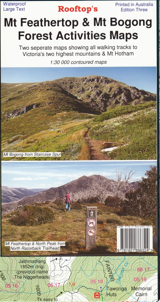
Mt Feathertop - Mt Bogong Forest Activities Map Rooftop
🏔️ Mt Feathertop – Mt Bogong Forest Activities Map
By Rooftop Maps | Topographic Explorer Series | Scale: 1:50,000
🌲 Your Companion for Alpine Adventure
This detailed topographic map from Rooftop’s trusted Forest Activities series is the ideal navigation tool for walkers, hikers, campers, and 4WD adventurers exploring the stunning alpine country between Mt Feathertop and Mt Bogong, including the iconic Mount Hotham and West Kiewa River valleys.
Whether you're climbing Victoria’s highest peak, traversing alpine saddles, or following heritage huts trails, this map provides reliable, GPS-ready detail in a compact, rugged format built for the outdoors.
🗺️ Map Coverage Includes:
-
Mt Feathertop & Razorback Ridge
-
Mt Bogong, Victoria’s highest mountain
-
Harrietville & Upper West Kiewa River
-
Mount Hotham Alpine Resort
-
Dibbins Hut & the Cobungra River
-
Surrounding forest reserves and alpine tracks
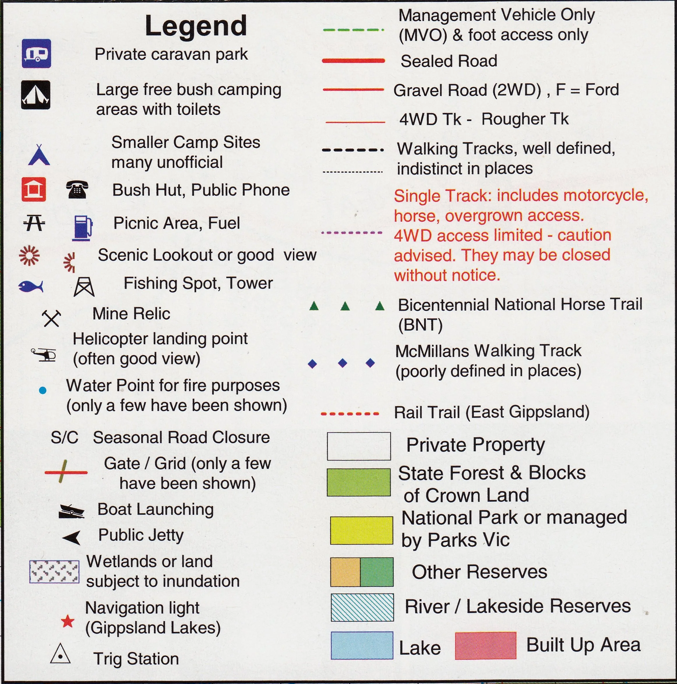
🧭 Key Map Features
| Feature | Description |
|---|---|
| 🥾 Walking Tracks | Clearly marked foot-access-only trails across alpine and subalpine terrain |
| 🚗 Roads & Tracks | Includes sealed, unsealed, and 4WD-accessible tracks |
| 🏕️ Bush Facilities | Camping areas, toilets, car parks, and huts marked with intuitive symbols |
| 📏 Topographic Detail | Contours, elevation shading, rivers, and ridgelines |
| 📌 Navigation-Ready | Includes GPS coordinates, grid references, and named waypoints for major features |
📍 Ideal For:
-
Multi-day bushwalkers tackling the Razorback to Bogong traverse
-
4WD tourers exploring the Alpine National Park
-
Cross-country skiers and snowshoers (in season)
-
Landscape photographers, nature lovers, and heritage trail hikers
🛡️ Optional Lamination
Want a more rugged finish? We can laminate this map in high-quality 80-micron gloss film, allowing you to:
-
✅ Write with whiteboard markers
-
✅ Apply and remove map dots to plan routes or mark locations
-
✅ Protect your map from tears, mud, and water in the field
Note: Laminated versions are created from previously folded maps, so light crease lines may remain.
📐 Specifications
| Attribute | Detail |
|---|---|
| Scale | 1:50,000 |
| Dimensions (Opened) | 1000 mm (H) x 700 mm (W) |
| Publisher | Rooftop Maps |
| Edition | Latest available |
| Format | Folded paper or laminated flat map |
| Made in | Australia |
🌟 Why Buy This Map?
✔️ The most detailed map available for this part of the Victorian Alps
✔️ Trusted by hikers, skiers, and outdoor guides across Australia
✔️ Locally made, topographically accurate, and GPS-compatible
✔️ Beautifully printed, field-tested, and built to last
Whether you're summiting Mt Feathertop at sunrise or tracing the hidden trails of Bogong’s high plains, this Rooftop map ensures you stay oriented, informed, and inspired.
🛒 Add it to your pack and hit the trail with confidence.

Description
🏔️ Mt Feathertop – Mt Bogong Forest Activities Map
By Rooftop Maps | Topographic Explorer Series | Scale: 1:50,000
🌲 Your Companion for Alpine Adventure
This detailed topographic map from Rooftop’s trusted Forest Activities series is the ideal navigation tool for walkers, hikers, campers, and 4WD adventurers exploring the stunning alpine country between Mt Feathertop and Mt Bogong, including the iconic Mount Hotham and West Kiewa River valleys.
Whether you're climbing Victoria’s highest peak, traversing alpine saddles, or following heritage huts trails, this map provides reliable, GPS-ready detail in a compact, rugged format built for the outdoors.
🗺️ Map Coverage Includes:
-
Mt Feathertop & Razorback Ridge
-
Mt Bogong, Victoria’s highest mountain
-
Harrietville & Upper West Kiewa River
-
Mount Hotham Alpine Resort
-
Dibbins Hut & the Cobungra River
-
Surrounding forest reserves and alpine tracks
🧭 Key Map Features
| Feature | Description |
|---|---|
| 🥾 Walking Tracks | Clearly marked foot-access-only trails across alpine and subalpine terrain |
| 🚗 Roads & Tracks | Includes sealed, unsealed, and 4WD-accessible tracks |
| 🏕️ Bush Facilities | Camping areas, toilets, car parks, and huts marked with intuitive symbols |
| 📏 Topographic Detail | Contours, elevation shading, rivers, and ridgelines |
| 📌 Navigation-Ready | Includes GPS coordinates, grid references, and named waypoints for major features |
📍 Ideal For:
-
Multi-day bushwalkers tackling the Razorback to Bogong traverse
-
4WD tourers exploring the Alpine National Park
-
Cross-country skiers and snowshoers (in season)
-
Landscape photographers, nature lovers, and heritage trail hikers
🛡️ Optional Lamination
Want a more rugged finish? We can laminate this map in high-quality 80-micron gloss film, allowing you to:
-
✅ Write with whiteboard markers
-
✅ Apply and remove map dots to plan routes or mark locations
-
✅ Protect your map from tears, mud, and water in the field
Note: Laminated versions are created from previously folded maps, so light crease lines may remain.
📐 Specifications
| Attribute | Detail |
|---|---|
| Scale | 1:50,000 |
| Dimensions (Opened) | 1000 mm (H) x 700 mm (W) |
| Publisher | Rooftop Maps |
| Edition | Latest available |
| Format | Folded paper or laminated flat map |
| Made in | Australia |
🌟 Why Buy This Map?
✔️ The most detailed map available for this part of the Victorian Alps
✔️ Trusted by hikers, skiers, and outdoor guides across Australia
✔️ Locally made, topographically accurate, and GPS-compatible
✔️ Beautifully printed, field-tested, and built to last
Whether you're summiting Mt Feathertop at sunrise or tracing the hidden trails of Bogong’s high plains, this Rooftop map ensures you stay oriented, informed, and inspired.
🛒 Add it to your pack and hit the trail with confidence.