New South Wales UBD 270 Map 1000 x 690mm Laminated Wall Map with Hang Rails
New South Wales UBD 270 — State & Greater Sydney Wall Map (Double-Sided, Laminated with Hang Rails)
Explore the state of New South Wales in detail with the UBD 270 Double-Sided Wall Map. Combining a statewide overview with a 75 km suburban radius of Sydney, this map is the perfect tool for planning, education, and display.
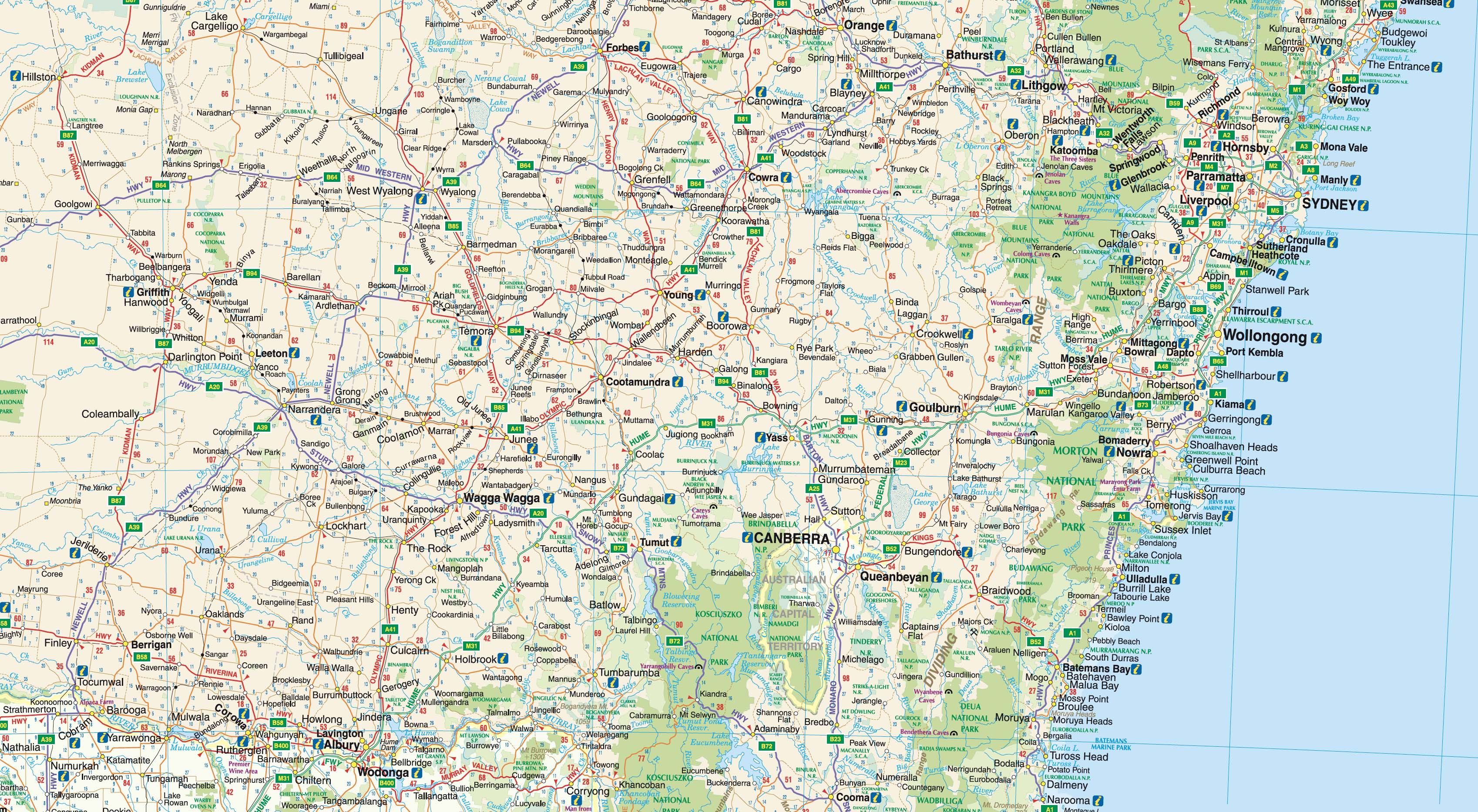
On one side, you’ll find the entire state of NSW at a scale of 1:1,600,000, with every major and minor town indexed for quick reference. Dual carriageways, national highways, and protected areas such as national parks and nature reserves are clearly indicated, making this map a practical choice for travellers, planners, and educators.
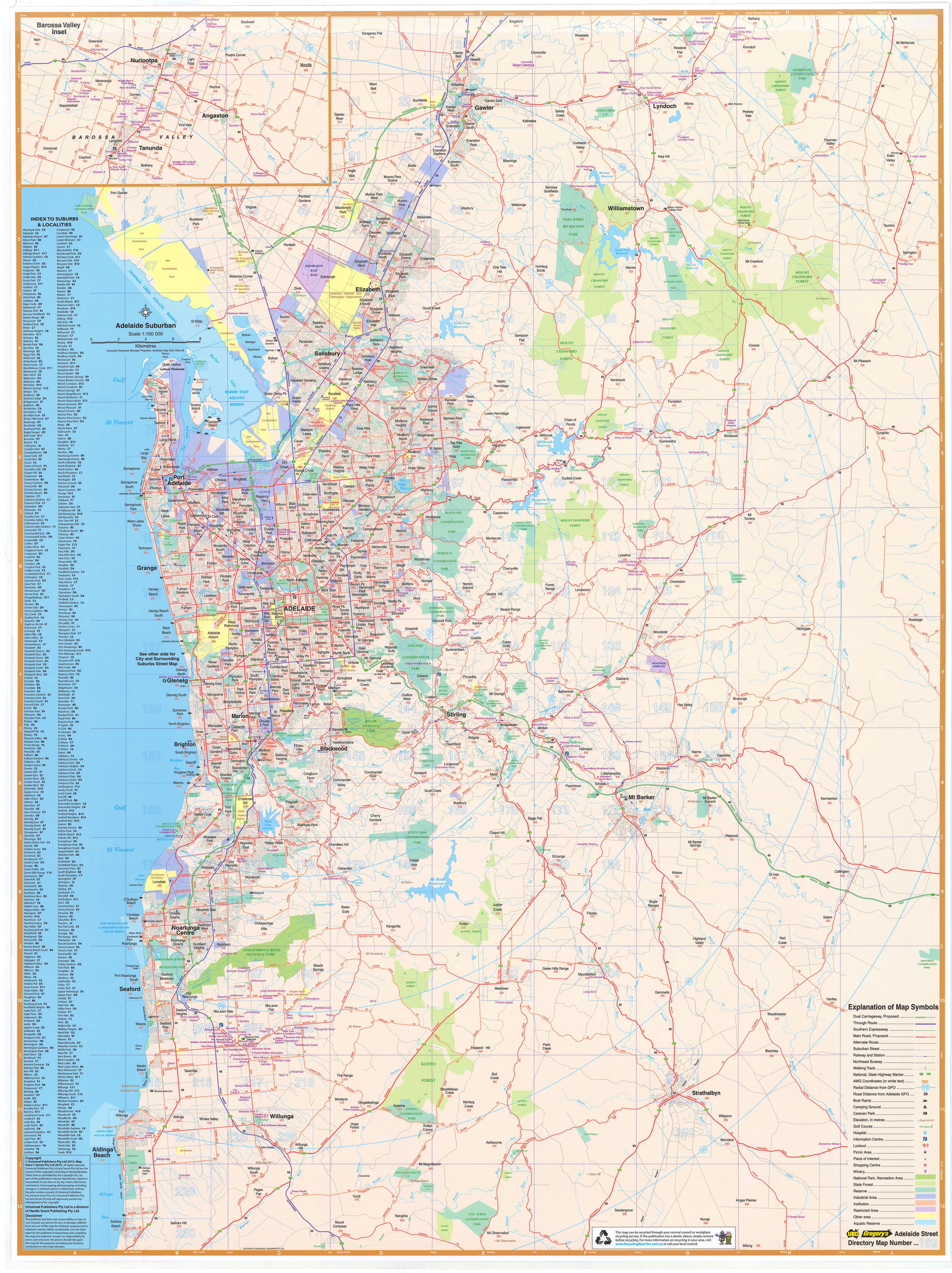
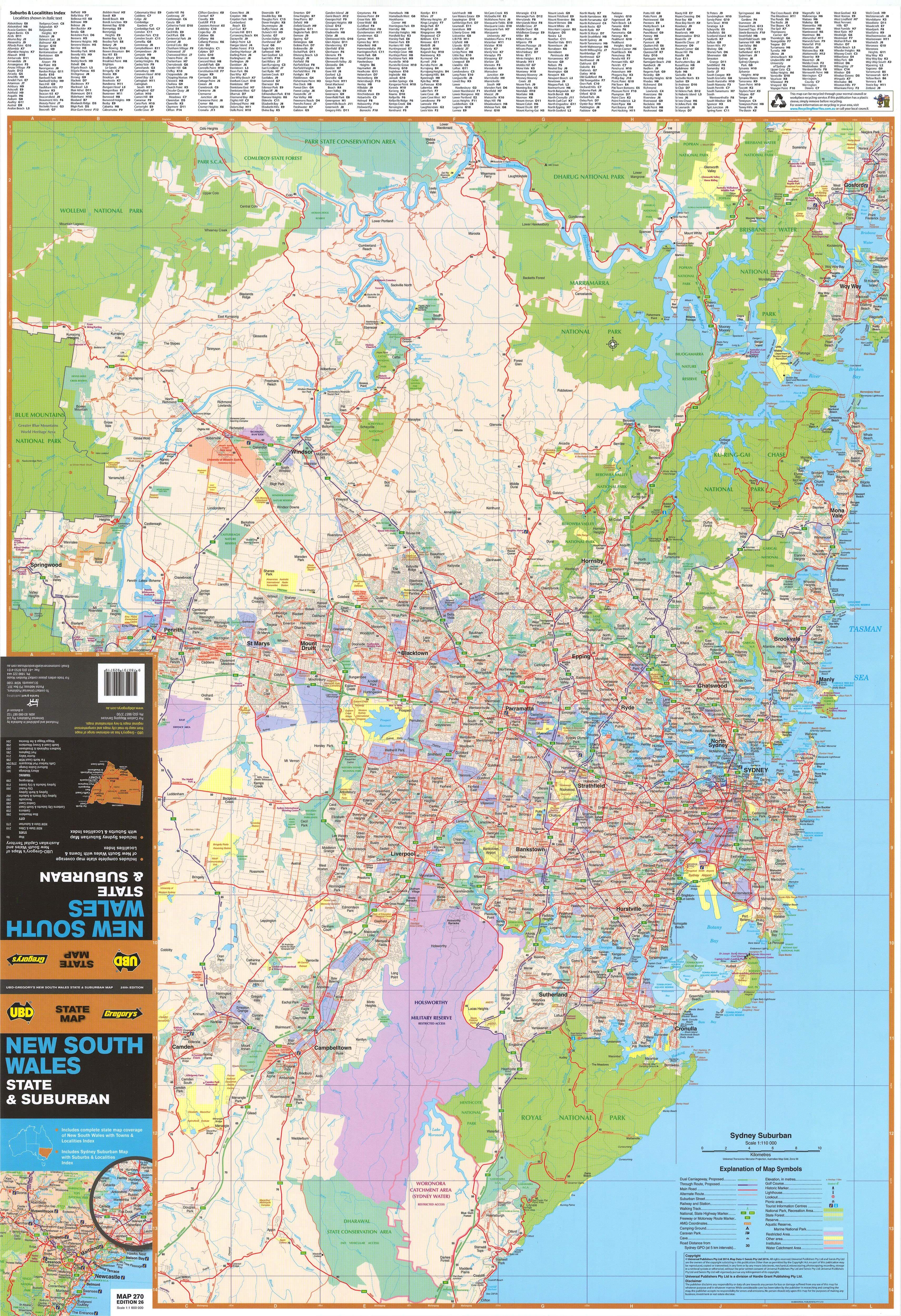
Flip to the reverse side, and you’ll discover the Greater Sydney metropolitan area at 1:110,000 scale. From Gosford in the north to Clifton in the south, and out to Springwood in the west, this detailed view highlights arterial routes, built-up suburban areas, industrial zones, and national parks. Each suburb is named, postcode-marked, and cross-referenced in a comprehensive index.
Whether used at home, in the office, or in a classroom, this double-sided wall map is both versatile and durable, designed for years of reference.
📍 Map Coverage
Side 1 — New South Wales State Map (Scale: 1:1,600,000)
-
Entire state coverage, including major and minor regional towns
-
Fully indexed for easy location searches
-
National highways, dual carriageways, and key routes marked
-
National parks and nature reserves clearly shown
Side 2 — Greater Sydney Suburban Map (Scale: 1:110,000)
-
75 km suburban radius of Sydney
-
Extends north to Gosford, south to Clifton, west to Springwood
-
Arterial routes, major roads, suburban areas, industrial zones, and national parks highlighted
-
Suburbs clearly labelled with postcodes, all indexed
🗝️ Key Features
-
Two maps in one — NSW state overview + Greater Sydney suburban radius
-
Town & suburb indexes — Regional towns and suburbs with postcodes fully indexed
-
Transport clarity — Highways, arterial routes, and major roads marked
-
Urban & natural context — Built-up areas, industrial zones, and national parks shown
-
Planning utility — Ideal for property planning, education, business, or logistics
-
Display-ready — Supplied laminated with timber hang rails and hanging cord
🎨 Premium Materials & Finish
-
Laminated (True Encapsulation):
-
Fully sealed in 2 × 80-micron gloss laminate, edge-protected for durability
-
Waterproof, tear-resistant, and stain-protected
-
Wipe-clean surface for long-term use
-
-
Interactive Surface:
Mark suburbs, towns, or routes with whiteboard markers or map dots — all erase cleanly without leaving permanent marks. -
Timber Hang Rails:
Natural timber rails, lacquered finish, attached top and bottom with a hanging cord for easy wall display. -
Australian Made:
Printed locally using pigment-based, fade-resistant inks for sharp, lasting clarity.
⚠️ Please allow up to 10 working days for delivery, as each hang-railed map is custom finished by our framer.
📐 Size & Scale
-
Size: 1000 mm × 690 mm (39.3" × 27.1")
-
Scales:
-
Side 1: 1:1,600,000 (Statewide NSW)
-
Side 2: 1:110,000 (Greater Sydney radius)
-
-
Orientation: Landscape
📊 Specifications
| Attribute | Details |
|---|---|
| Title | New South Wales UBD 270 Wall Map |
| Scales | 1:1,600,000 (NSW State) / 1:110,000 (Greater Sydney radius) |
| Coverage | NSW statewide + Greater Sydney suburbs (Gosford–Clifton–Springwood) |
| Indexes | Major & minor towns; suburb & postcode index |
| Print Size | 1000 mm × 690 mm |
| Format | Laminated + Timber Hang Rails |
| Laminate | 2 × 80-micron gloss (true encapsulation) |
| Hang Rails | Natural timber, lacquered; with top hanging cord |
| Inks | Pigment-based, fade-resistant |
| Origin | Printed in Australia |
🎯 Who it’s for
-
🏠 Households & property buyers — Understand state and metro layouts at a glance
-
🏢 Businesses & offices — Use as a planning and logistics reference
-
🚛 Transport & delivery teams — Route planning from regional towns to metro suburbs
-
🎓 Schools, universities & libraries — A practical teaching resource for geography and planning
-
📍 Community spaces — A versatile, durable map for public display
🤝 Our Commitment
Every UBD wall map is printed, laminated, and finished locally in Australia. Each one is colour-managed, hand-checked, and carefully packed, ensuring it arrives ready to display.
Durable enough for daily use, accurate enough for planning, and handsome enough to hang proudly.
🛒 Order your New South Wales UBD 270 Wall Map today — a complete view of the state and Greater Sydney in one display-ready map.
Original: $255.00
-70%$255.00
$76.50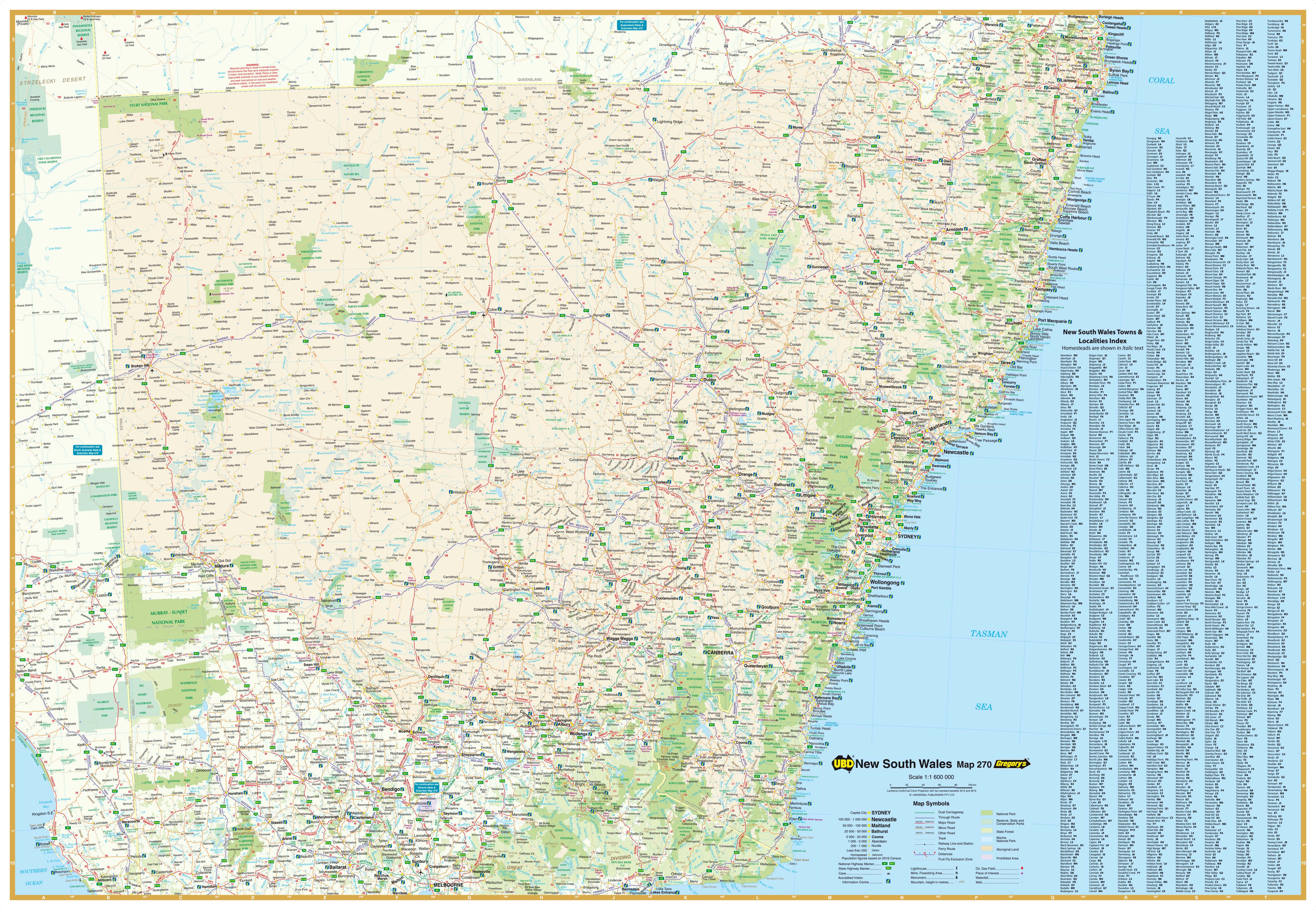
Description
New South Wales UBD 270 — State & Greater Sydney Wall Map (Double-Sided, Laminated with Hang Rails)
Explore the state of New South Wales in detail with the UBD 270 Double-Sided Wall Map. Combining a statewide overview with a 75 km suburban radius of Sydney, this map is the perfect tool for planning, education, and display.
On one side, you’ll find the entire state of NSW at a scale of 1:1,600,000, with every major and minor town indexed for quick reference. Dual carriageways, national highways, and protected areas such as national parks and nature reserves are clearly indicated, making this map a practical choice for travellers, planners, and educators.
Flip to the reverse side, and you’ll discover the Greater Sydney metropolitan area at 1:110,000 scale. From Gosford in the north to Clifton in the south, and out to Springwood in the west, this detailed view highlights arterial routes, built-up suburban areas, industrial zones, and national parks. Each suburb is named, postcode-marked, and cross-referenced in a comprehensive index.
Whether used at home, in the office, or in a classroom, this double-sided wall map is both versatile and durable, designed for years of reference.
📍 Map Coverage
Side 1 — New South Wales State Map (Scale: 1:1,600,000)
-
Entire state coverage, including major and minor regional towns
-
Fully indexed for easy location searches
-
National highways, dual carriageways, and key routes marked
-
National parks and nature reserves clearly shown
Side 2 — Greater Sydney Suburban Map (Scale: 1:110,000)
-
75 km suburban radius of Sydney
-
Extends north to Gosford, south to Clifton, west to Springwood
-
Arterial routes, major roads, suburban areas, industrial zones, and national parks highlighted
-
Suburbs clearly labelled with postcodes, all indexed
🗝️ Key Features
-
Two maps in one — NSW state overview + Greater Sydney suburban radius
-
Town & suburb indexes — Regional towns and suburbs with postcodes fully indexed
-
Transport clarity — Highways, arterial routes, and major roads marked
-
Urban & natural context — Built-up areas, industrial zones, and national parks shown
-
Planning utility — Ideal for property planning, education, business, or logistics
-
Display-ready — Supplied laminated with timber hang rails and hanging cord
🎨 Premium Materials & Finish
-
Laminated (True Encapsulation):
-
Fully sealed in 2 × 80-micron gloss laminate, edge-protected for durability
-
Waterproof, tear-resistant, and stain-protected
-
Wipe-clean surface for long-term use
-
-
Interactive Surface:
Mark suburbs, towns, or routes with whiteboard markers or map dots — all erase cleanly without leaving permanent marks. -
Timber Hang Rails:
Natural timber rails, lacquered finish, attached top and bottom with a hanging cord for easy wall display. -
Australian Made:
Printed locally using pigment-based, fade-resistant inks for sharp, lasting clarity.
⚠️ Please allow up to 10 working days for delivery, as each hang-railed map is custom finished by our framer.
📐 Size & Scale
-
Size: 1000 mm × 690 mm (39.3" × 27.1")
-
Scales:
-
Side 1: 1:1,600,000 (Statewide NSW)
-
Side 2: 1:110,000 (Greater Sydney radius)
-
-
Orientation: Landscape
📊 Specifications
| Attribute | Details |
|---|---|
| Title | New South Wales UBD 270 Wall Map |
| Scales | 1:1,600,000 (NSW State) / 1:110,000 (Greater Sydney radius) |
| Coverage | NSW statewide + Greater Sydney suburbs (Gosford–Clifton–Springwood) |
| Indexes | Major & minor towns; suburb & postcode index |
| Print Size | 1000 mm × 690 mm |
| Format | Laminated + Timber Hang Rails |
| Laminate | 2 × 80-micron gloss (true encapsulation) |
| Hang Rails | Natural timber, lacquered; with top hanging cord |
| Inks | Pigment-based, fade-resistant |
| Origin | Printed in Australia |
🎯 Who it’s for
-
🏠 Households & property buyers — Understand state and metro layouts at a glance
-
🏢 Businesses & offices — Use as a planning and logistics reference
-
🚛 Transport & delivery teams — Route planning from regional towns to metro suburbs
-
🎓 Schools, universities & libraries — A practical teaching resource for geography and planning
-
📍 Community spaces — A versatile, durable map for public display
🤝 Our Commitment
Every UBD wall map is printed, laminated, and finished locally in Australia. Each one is colour-managed, hand-checked, and carefully packed, ensuring it arrives ready to display.
Durable enough for daily use, accurate enough for planning, and handsome enough to hang proudly.
🛒 Order your New South Wales UBD 270 Wall Map today — a complete view of the state and Greater Sydney in one display-ready map.