Northern California Recreation 711 x 1016mm Wall Map
🌲 Northern California Recreation Wall Map – 2022 Edition
Published: 2022 | Scale: 1:659,000 | Size: 711 mm (W) × 1016 mm (H)
From the soaring Redwood forests of the Pacific Coast to the rugged granite walls of Yosemite Valley, Northern California is a landscape of contrasts and wonders. This detailed wall map captures the northern half of The Golden State, highlighting its vast network of public lands, scenic roadways, and outdoor destinations. Whether your journey takes you to Lake Tahoe, San Francisco Bay, Mount Shasta, or the Sierra Nevada Mountains, this map provides both clarity and inspiration.
🗺 Key Features
-
Complete Northern California Coverage – From the Oregon border down to the Central Valley.
-
Public Lands Highlighted – National and state parks, forests, and recreation areas clearly marked.
-
Road Network Detail – Major highways, scenic byways, and secondary routes.
-
Topographic Shaded Relief – Depicts mountains, valleys, and coastal terrain.
-
Inset Detail – Major destinations such as Yosemite, San Francisco Bay, and Lake Tahoe.
-
Clear Cartography – Labels positioned for optimal readability.
📐 Size & Scale
| Dimensions | Scale | Edition |
|---|---|---|
| 711 × 1016 mm | 1:659,000 | 2022 |
🖌 Premium Material & Display Options
| Format | Description |
|---|---|
| Paper (160 gsm) | Heavyweight matte-coated stock — perfect for framing under glass. |
| Laminated | Encapsulated in 80-micron gloss laminate — durable, waterproof, and suitable for whiteboard markers. |
| Laminated + Hang Rails | Professionally mounted with natural timber rails — ready to hang. |
| Canvas (395 gsm) | Museum-grade matte canvas with archival pigment inks — textured, fade-resistant, and built to last. |
| Canvas + Hang Rails | Canvas mounted with lacquered timber rails — a premium display solution. |
Note: Please allow up to 10 working days for delivery of hang-railed maps due to custom mounting.
🎯 Perfect For
-
Travel Planners – Plan road trips through California’s most scenic regions.
-
Outdoor Enthusiasts – Locate trailheads, parks, and recreation areas.
-
Educators & Tourism Centres – Excellent for geography classrooms and visitor hubs.
-
Collectors – Complements the full U.S. state recreation wall map series.
🌟 Why Choose This Map
-
Comprehensive Coverage – Focused on the northern half of California, from coast to mountains.
-
Decorative & Functional – Works equally well as a planning tool or wall feature.
-
Premium Quality – Long-lasting materials and vivid printing.
-
Proudly Made in Australia – Crafted to the highest cartographic standards.
The Northern California Recreation Wall Map is your gateway to the state’s most iconic landscapes and recreation destinations, providing both practical navigation and a stunning visual showcase.
Original: $79.95
-70%$79.95
$23.98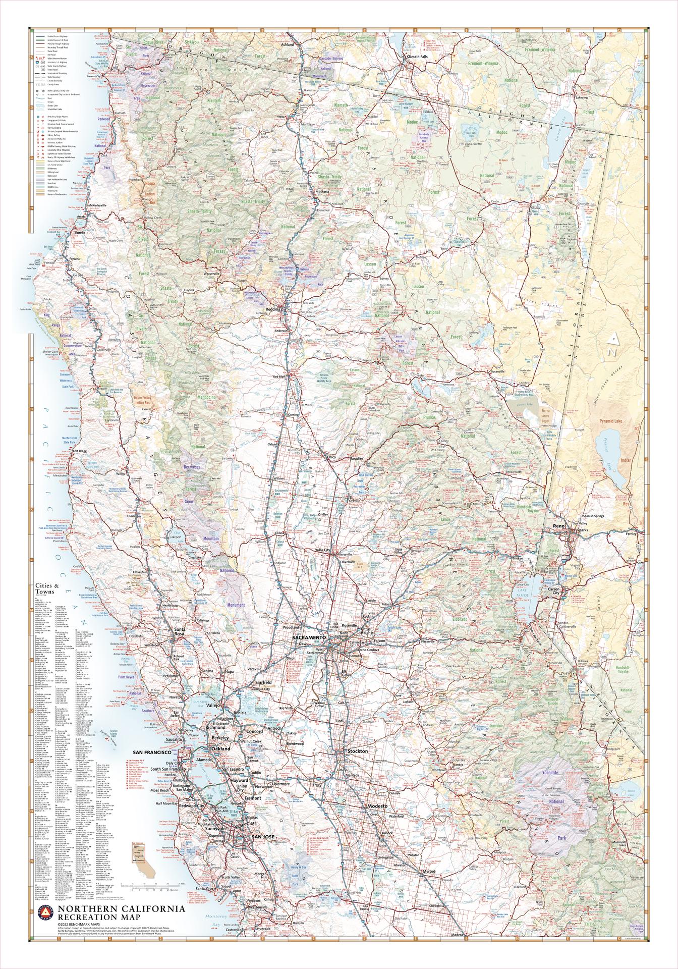
Description
🌲 Northern California Recreation Wall Map – 2022 Edition
Published: 2022 | Scale: 1:659,000 | Size: 711 mm (W) × 1016 mm (H)
From the soaring Redwood forests of the Pacific Coast to the rugged granite walls of Yosemite Valley, Northern California is a landscape of contrasts and wonders. This detailed wall map captures the northern half of The Golden State, highlighting its vast network of public lands, scenic roadways, and outdoor destinations. Whether your journey takes you to Lake Tahoe, San Francisco Bay, Mount Shasta, or the Sierra Nevada Mountains, this map provides both clarity and inspiration.
🗺 Key Features
-
Complete Northern California Coverage – From the Oregon border down to the Central Valley.
-
Public Lands Highlighted – National and state parks, forests, and recreation areas clearly marked.
-
Road Network Detail – Major highways, scenic byways, and secondary routes.
-
Topographic Shaded Relief – Depicts mountains, valleys, and coastal terrain.
-
Inset Detail – Major destinations such as Yosemite, San Francisco Bay, and Lake Tahoe.
-
Clear Cartography – Labels positioned for optimal readability.
📐 Size & Scale
| Dimensions | Scale | Edition |
|---|---|---|
| 711 × 1016 mm | 1:659,000 | 2022 |
🖌 Premium Material & Display Options
| Format | Description |
|---|---|
| Paper (160 gsm) | Heavyweight matte-coated stock — perfect for framing under glass. |
| Laminated | Encapsulated in 80-micron gloss laminate — durable, waterproof, and suitable for whiteboard markers. |
| Laminated + Hang Rails | Professionally mounted with natural timber rails — ready to hang. |
| Canvas (395 gsm) | Museum-grade matte canvas with archival pigment inks — textured, fade-resistant, and built to last. |
| Canvas + Hang Rails | Canvas mounted with lacquered timber rails — a premium display solution. |
Note: Please allow up to 10 working days for delivery of hang-railed maps due to custom mounting.
🎯 Perfect For
-
Travel Planners – Plan road trips through California’s most scenic regions.
-
Outdoor Enthusiasts – Locate trailheads, parks, and recreation areas.
-
Educators & Tourism Centres – Excellent for geography classrooms and visitor hubs.
-
Collectors – Complements the full U.S. state recreation wall map series.
🌟 Why Choose This Map
-
Comprehensive Coverage – Focused on the northern half of California, from coast to mountains.
-
Decorative & Functional – Works equally well as a planning tool or wall feature.
-
Premium Quality – Long-lasting materials and vivid printing.
-
Proudly Made in Australia – Crafted to the highest cartographic standards.
The Northern California Recreation Wall Map is your gateway to the state’s most iconic landscapes and recreation destinations, providing both practical navigation and a stunning visual showcase.