South West Western Australia Hema 1430 x 1000mm Supermap Laminated Wall Map
An Oversized and Exceptionally Detailed Map for Touring, Planning & Exploring
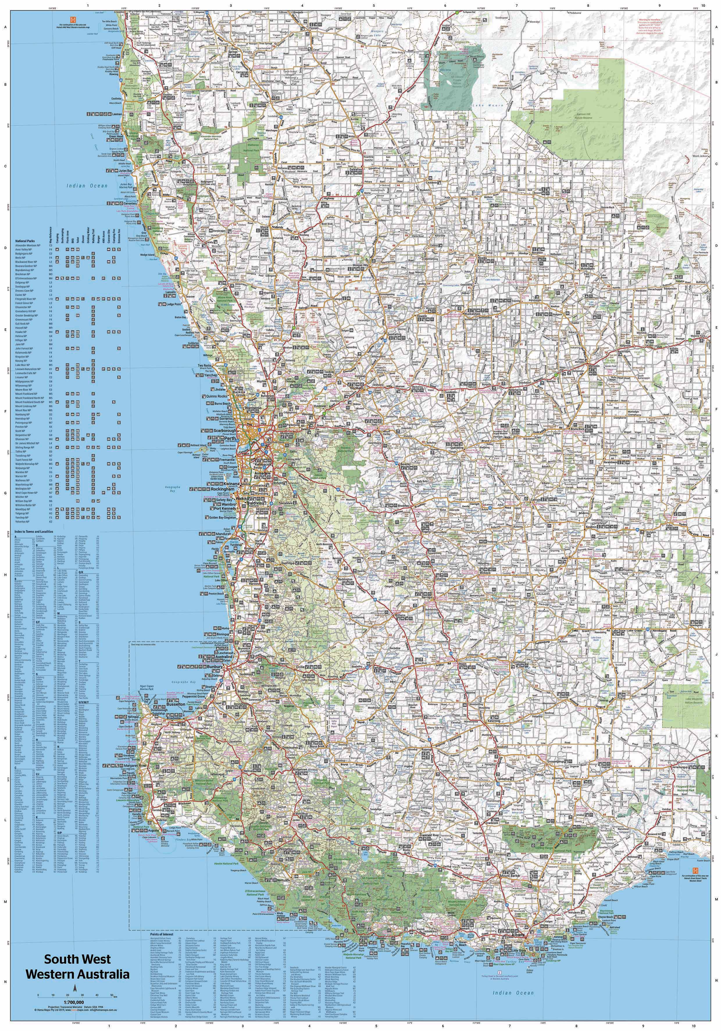
Discover one of Australia’s most captivating regions in extraordinary detail with this supersized laminated wall map of South West Western Australia by Hema Maps. At an impressive 1430 mm x 1000 mm, this is Hema’s most comprehensive wall map of the area, combining road, 4WD track, and regional information into one high-impact format ideal for homes, offices, classrooms, or trip planning spaces.
This latest edition includes significantly expanded coverage of off-road tracks, offering far greater detail for 4WD adventurers and overland tourers than ever before. Whether you're meandering through wine country, exploring national parks, or plotting a remote escape along WA's southern coast, this is the ultimate planning companion.
🗺️ Key Features
-
Road & Track Detail:
Accurate, GPS-surveyed mapping of all major roads, regional routes, and a huge network of secondary tracks and 4WD trails. Road classifications are clearly marked for easy route planning. -
National & Regional Parks:
Green shaded park areas with inset detail for major national parks – ideal for bushwalking, nature trips, and camping. -
Camping & Caravan Facilities:
Clearly marked campgrounds, rest areas, and caravan parks across the South West. -
Tourist Icons:
Points of interest including scenic drives, geological features, waterfalls, coastal lookouts, wineries, and historical sites. -
Inset Maps:
National Park inset maps with more detail for high-interest areas.
✏️ Laminated & Ready for Use
This map is laminated using 80-micron gloss encapsulation, making it:
-
Durable and long-lasting
-
Water-resistant and easy to clean
-
Writable with whiteboard markers – plan your itinerary or mark must-see places
-
Compatible with Mark-It Dots to highlight favourite spots
Perfect for:
-
Trip planning on a kitchen or office wall
-
Caravan and 4WD enthusiasts mapping travel routes
-
Educators and businesses requiring regional reference tools
-
Tour operators and local tourism offices
📐 Specifications
| Attribute | Details |
|---|---|
| Title | South West Western Australia Supermap |
| Map Series | Hema Wall Maps |
| Scale | 1:500,000 |
| Format | Laminated Wall Map (Encapsulated) |
| Size | 1430 mm (h) × 1000 mm (w) |
| Edition | Latest release with updated 4WD tracks |
| Publisher | Hema Maps |
| Made in | Australia |
🌏 Region Coverage Includes:
-
Margaret River & the wine region
-
Albany, Denmark, and the Rainbow Coast
-
Busselton and the Geographe Bay coastline
-
Karri forests of Pemberton and Northcliffe
-
Stirling Range & Porongurup National Parks
-
Bunbury, Collie, Manjimup, Augusta & Cape Leeuwin
-
Inland towns, scenic loops, and remote tracks
Whether you're a weekend camper, a seasoned four-wheel driver, or just fascinated by Western Australia's dramatic landscapes, this map brings South West WA to life with clarity, scale, and practical detail.
Description
An Oversized and Exceptionally Detailed Map for Touring, Planning & Exploring
Discover one of Australia’s most captivating regions in extraordinary detail with this supersized laminated wall map of South West Western Australia by Hema Maps. At an impressive 1430 mm x 1000 mm, this is Hema’s most comprehensive wall map of the area, combining road, 4WD track, and regional information into one high-impact format ideal for homes, offices, classrooms, or trip planning spaces.
This latest edition includes significantly expanded coverage of off-road tracks, offering far greater detail for 4WD adventurers and overland tourers than ever before. Whether you're meandering through wine country, exploring national parks, or plotting a remote escape along WA's southern coast, this is the ultimate planning companion.
🗺️ Key Features
-
Road & Track Detail:
Accurate, GPS-surveyed mapping of all major roads, regional routes, and a huge network of secondary tracks and 4WD trails. Road classifications are clearly marked for easy route planning. -
National & Regional Parks:
Green shaded park areas with inset detail for major national parks – ideal for bushwalking, nature trips, and camping. -
Camping & Caravan Facilities:
Clearly marked campgrounds, rest areas, and caravan parks across the South West. -
Tourist Icons:
Points of interest including scenic drives, geological features, waterfalls, coastal lookouts, wineries, and historical sites. -
Inset Maps:
National Park inset maps with more detail for high-interest areas.
✏️ Laminated & Ready for Use
This map is laminated using 80-micron gloss encapsulation, making it:
-
Durable and long-lasting
-
Water-resistant and easy to clean
-
Writable with whiteboard markers – plan your itinerary or mark must-see places
-
Compatible with Mark-It Dots to highlight favourite spots
Perfect for:
-
Trip planning on a kitchen or office wall
-
Caravan and 4WD enthusiasts mapping travel routes
-
Educators and businesses requiring regional reference tools
-
Tour operators and local tourism offices
📐 Specifications
| Attribute | Details |
|---|---|
| Title | South West Western Australia Supermap |
| Map Series | Hema Wall Maps |
| Scale | 1:500,000 |
| Format | Laminated Wall Map (Encapsulated) |
| Size | 1430 mm (h) × 1000 mm (w) |
| Edition | Latest release with updated 4WD tracks |
| Publisher | Hema Maps |
| Made in | Australia |
🌏 Region Coverage Includes:
-
Margaret River & the wine region
-
Albany, Denmark, and the Rainbow Coast
-
Busselton and the Geographe Bay coastline
-
Karri forests of Pemberton and Northcliffe
-
Stirling Range & Porongurup National Parks
-
Bunbury, Collie, Manjimup, Augusta & Cape Leeuwin
-
Inland towns, scenic loops, and remote tracks
Whether you're a weekend camper, a seasoned four-wheel driver, or just fascinated by Western Australia's dramatic landscapes, this map brings South West WA to life with clarity, scale, and practical detail.


