The "Rocks" Sydney 1886-1890 Vintage Print
A Vision of a Remade Sydney | Historic Architectural Plan Reproduction
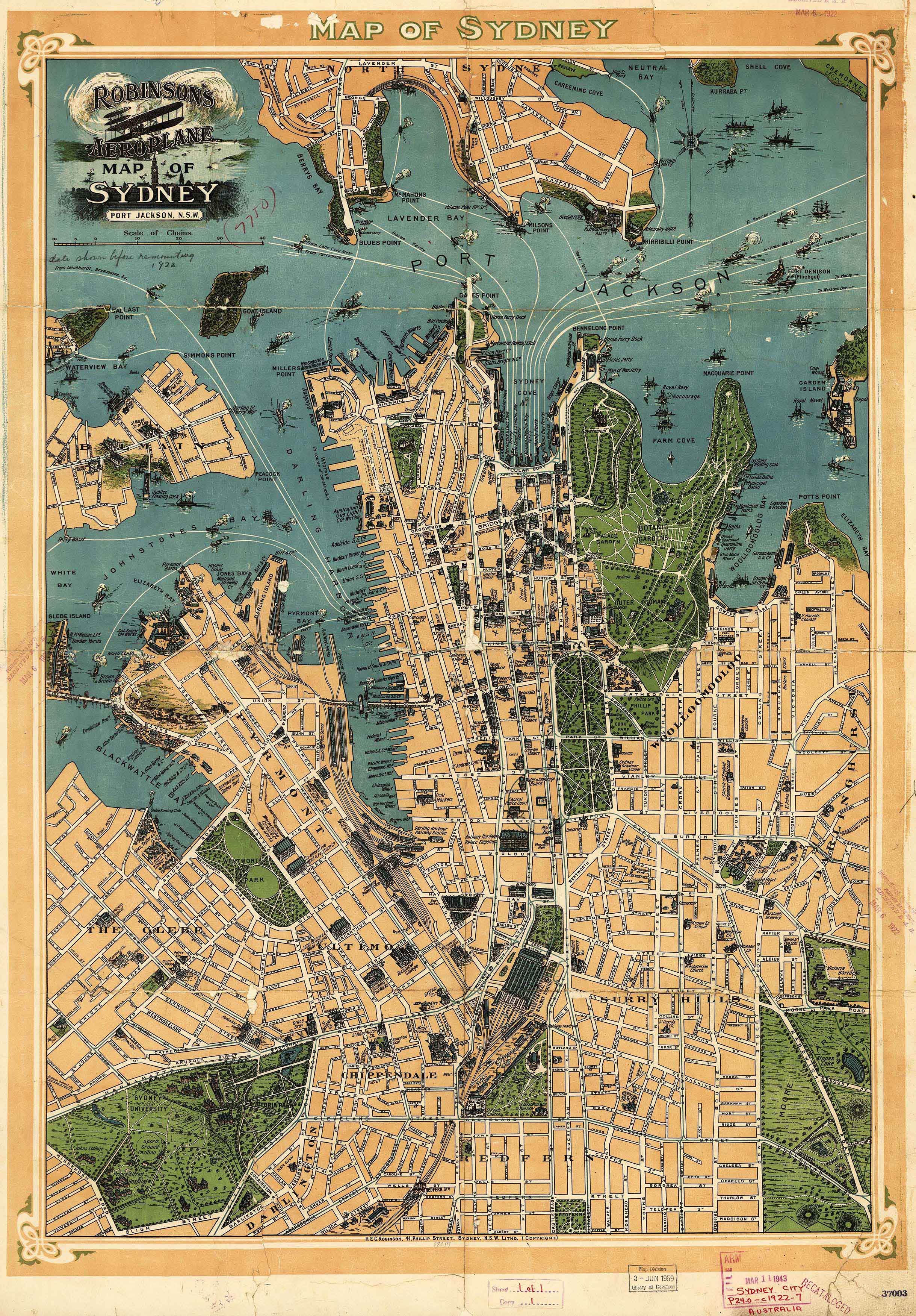
This captivating historical print, titled “The ‘Rocks’ Remodelled with a City Railway and New George Street North,” is a rare illustration of Sydney’s late 19th-century ambitions, as proposed by renowned engineer Norman Selfe, M.I.C.E. Produced between 1886 and 1890, the print depicts a grand reimagining of The Rocks district, complete with a city railway extension and a newly planned George Street North—an early and visionary attempt to modernise the harbour city.
Drawn in an era of bold urban planning, this piece captures not just a map, but a moment in the imagination of Sydney’s transformation.
Historical Context & Significance
-
Illustrator: Norman Selfe, M.I.C.E., a pioneer of Sydney’s urban infrastructure
-
Subject: Proposed remodelling of The Rocks and a city railway extension
-
Era: 1886–1890, during a period of rapid industrial growth and modernisation in New South Wales
-
Focus: George Street North realignment and The Rocks redevelopment plan
This is more than a map—it's a window into a Sydney that might have been.
Available Formats & Materials
| Finish Type | Description |
|---|---|
| 160gsm Premium Paper | Smooth matte finish, ideal for framing under glass |
| Laminated (Gloss) | True encapsulation with 80-micron gloss laminate—waterproof and wipeable |
| 395gsm Matte Canvas | Museum-grade HP Matte Canvas with pigment-based archival inks for exceptional clarity, durability, and fade resistance |
Canvas Hanging Option
Laminated & Canvas versions can be supplied with timber hang rails (top and bottom), lacquered in a natural wood finish and fitted with a hanging cord—perfect for effortless, elegant wall display.
⏳ Please allow up to 10 working days for framed canvas versions, as these are custom-fitted by our framer.
📐 Available Sizes
| Format | Dimensions (W x H) |
|---|---|
| Standard | 800 mm x 520 mm |
| Large | 1150 mm x 750 mm |
Choose your preferred size and finish using the dropdown menu above.
✅ Why This Piece?
| Feature | Benefit |
|---|---|
| Authentic historical content | A rare insight into Sydney’s urban vision |
| Expert reproduction | Scanned and printed at high resolution |
| Gallery-quality materials | Archival paper, laminate, or canvas options |
| Perfect for historians, architects, and Sydney enthusiasts | A striking conversation piece and educational tool |
Whether you're a collector of historical prints, a lover of Sydney’s urban history, or looking to add a meaningful visual narrative to your wall, this extraordinary rendering of The Rocks and the Norman Selfe railway proposal offers timeless intrigue and character.
Original: $59.95
-70%$59.95
$17.98
Description
A Vision of a Remade Sydney | Historic Architectural Plan Reproduction
This captivating historical print, titled “The ‘Rocks’ Remodelled with a City Railway and New George Street North,” is a rare illustration of Sydney’s late 19th-century ambitions, as proposed by renowned engineer Norman Selfe, M.I.C.E. Produced between 1886 and 1890, the print depicts a grand reimagining of The Rocks district, complete with a city railway extension and a newly planned George Street North—an early and visionary attempt to modernise the harbour city.
Drawn in an era of bold urban planning, this piece captures not just a map, but a moment in the imagination of Sydney’s transformation.
Historical Context & Significance
-
Illustrator: Norman Selfe, M.I.C.E., a pioneer of Sydney’s urban infrastructure
-
Subject: Proposed remodelling of The Rocks and a city railway extension
-
Era: 1886–1890, during a period of rapid industrial growth and modernisation in New South Wales
-
Focus: George Street North realignment and The Rocks redevelopment plan
This is more than a map—it's a window into a Sydney that might have been.
Available Formats & Materials
| Finish Type | Description |
|---|---|
| 160gsm Premium Paper | Smooth matte finish, ideal for framing under glass |
| Laminated (Gloss) | True encapsulation with 80-micron gloss laminate—waterproof and wipeable |
| 395gsm Matte Canvas | Museum-grade HP Matte Canvas with pigment-based archival inks for exceptional clarity, durability, and fade resistance |
Canvas Hanging Option
Laminated & Canvas versions can be supplied with timber hang rails (top and bottom), lacquered in a natural wood finish and fitted with a hanging cord—perfect for effortless, elegant wall display.
⏳ Please allow up to 10 working days for framed canvas versions, as these are custom-fitted by our framer.
📐 Available Sizes
| Format | Dimensions (W x H) |
|---|---|
| Standard | 800 mm x 520 mm |
| Large | 1150 mm x 750 mm |
Choose your preferred size and finish using the dropdown menu above.
✅ Why This Piece?
| Feature | Benefit |
|---|---|
| Authentic historical content | A rare insight into Sydney’s urban vision |
| Expert reproduction | Scanned and printed at high resolution |
| Gallery-quality materials | Archival paper, laminate, or canvas options |
| Perfect for historians, architects, and Sydney enthusiasts | A striking conversation piece and educational tool |
Whether you're a collector of historical prints, a lover of Sydney’s urban history, or looking to add a meaningful visual narrative to your wall, this extraordinary rendering of The Rocks and the Norman Selfe railway proposal offers timeless intrigue and character.