World Hema Political (Pacific) Classic 1010 x 650mm Large Paper Wall Map
Classic Style | 1010 mm x 650 mm | High-Quality Paper Print
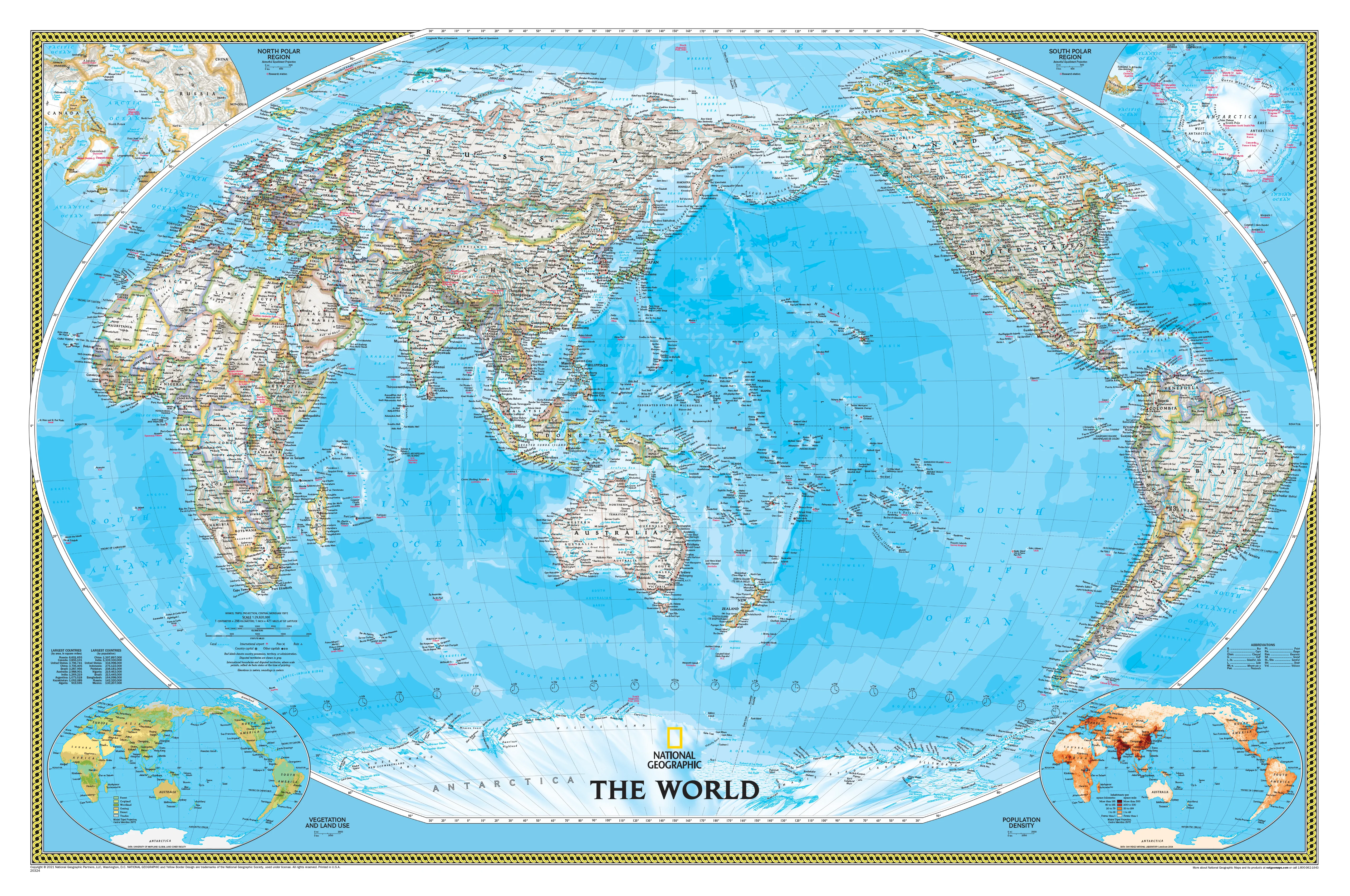
A Fresh Perspective of the World – Centred on the Pacific
The World Political (Pacific Centred) Map by Hema is a visually striking, highly detailed political map that shifts the traditional global view to centre on the vast Pacific Ocean—a perspective especially valuable for those in Australia, New Zealand, and the wider Asia-Pacific region.
Unlike standard Atlantic-centred maps, this format places our region at the heart of the world stage—offering a more intuitive view for travel planning, educational settings, or those simply wanting to see the globe from where they stand.
🧭 Map Highlights
-
🌐 Pacific-Centred Projection – Ideal for Australia and the Asia-Pacific region
-
🗺️ Clear Country Borders – Defined using light pastel colour blocks for visual clarity
-
🌊 Ocean Depth Shading – Deep, rich blues illustrate bathymetric contours across oceans
-
🧱 Detailed Political Boundaries – All sovereign states and capital cities clearly marked
-
🏙️ Accurate Labelling – Includes place names, capital cities, and regional distinctions
-
📐 Winkel Tripel Projection – Reduces distortion of landmasses at the poles
🖨️ Premium Print Quality
This map is printed on 170 gsm heavyweight matte-coated paper, offering:
-
A non-reflective surface—perfect for framing under glass
-
Pigment-based inks by Hewlett-Packard for crisp detail and fade resistance
-
Durable construction suited for long-term display in any environment
📏 Specifications
| Feature | Detail |
|---|---|
| Scale | 1:30,000,000 |
| Size (Open) | 1010 mm (w) x 650 mm (h) |
| Paper Stock | 170 gsm matte-coated |
| Ink | Pigment-based, fade-resistant |
| Publisher | Hema Maps |
| Projection | Pacific-centred Winkel Tripel |
| Made In | Australia |
🏡 Perfect For:
-
🏠 Home Decor – A sleek, understated map for your study, hallway, or living room
-
🏫 Classroom Learning – An essential resource for teaching world geography from an Asia-Pacific lens
-
🏢 Offices & Boardrooms – Add a professional, global outlook to your workspace
-
✈️ Travel Planning – Ideal for marking out adventures or visualising trade & migration routes
🧠 Why Choose Hema?
✅ Trusted Australian publisher known for clarity and precision
✅ Designed with the Southern Hemisphere in mind
✅ Elegant yet informative – a statement piece that educates as much as it decorates
✅ Built to last – using archival-quality materials
📦 Ships rolled in a secure mailing tube for safe delivery.
🖼️ Frame it under glass for maximum effect and longevity.
🌍 See the world the way you live in it—with the Pacific front and centre.

Description
Classic Style | 1010 mm x 650 mm | High-Quality Paper Print
A Fresh Perspective of the World – Centred on the Pacific
The World Political (Pacific Centred) Map by Hema is a visually striking, highly detailed political map that shifts the traditional global view to centre on the vast Pacific Ocean—a perspective especially valuable for those in Australia, New Zealand, and the wider Asia-Pacific region.
Unlike standard Atlantic-centred maps, this format places our region at the heart of the world stage—offering a more intuitive view for travel planning, educational settings, or those simply wanting to see the globe from where they stand.
🧭 Map Highlights
-
🌐 Pacific-Centred Projection – Ideal for Australia and the Asia-Pacific region
-
🗺️ Clear Country Borders – Defined using light pastel colour blocks for visual clarity
-
🌊 Ocean Depth Shading – Deep, rich blues illustrate bathymetric contours across oceans
-
🧱 Detailed Political Boundaries – All sovereign states and capital cities clearly marked
-
🏙️ Accurate Labelling – Includes place names, capital cities, and regional distinctions
-
📐 Winkel Tripel Projection – Reduces distortion of landmasses at the poles
🖨️ Premium Print Quality
This map is printed on 170 gsm heavyweight matte-coated paper, offering:
-
A non-reflective surface—perfect for framing under glass
-
Pigment-based inks by Hewlett-Packard for crisp detail and fade resistance
-
Durable construction suited for long-term display in any environment
📏 Specifications
| Feature | Detail |
|---|---|
| Scale | 1:30,000,000 |
| Size (Open) | 1010 mm (w) x 650 mm (h) |
| Paper Stock | 170 gsm matte-coated |
| Ink | Pigment-based, fade-resistant |
| Publisher | Hema Maps |
| Projection | Pacific-centred Winkel Tripel |
| Made In | Australia |
🏡 Perfect For:
-
🏠 Home Decor – A sleek, understated map for your study, hallway, or living room
-
🏫 Classroom Learning – An essential resource for teaching world geography from an Asia-Pacific lens
-
🏢 Offices & Boardrooms – Add a professional, global outlook to your workspace
-
✈️ Travel Planning – Ideal for marking out adventures or visualising trade & migration routes
🧠 Why Choose Hema?
✅ Trusted Australian publisher known for clarity and precision
✅ Designed with the Southern Hemisphere in mind
✅ Elegant yet informative – a statement piece that educates as much as it decorates
✅ Built to last – using archival-quality materials
📦 Ships rolled in a secure mailing tube for safe delivery.
🖼️ Frame it under glass for maximum effect and longevity.
🌍 See the world the way you live in it—with the Pacific front and centre.