World Political National Geographic 1759 x 1219mm (Africa Centred) Super Wall Map
By National Geographic
Elegant • Educational • Africa-Focused Perspective
🗺️ A Masterpiece of Political Geography – with Africa at the Heart
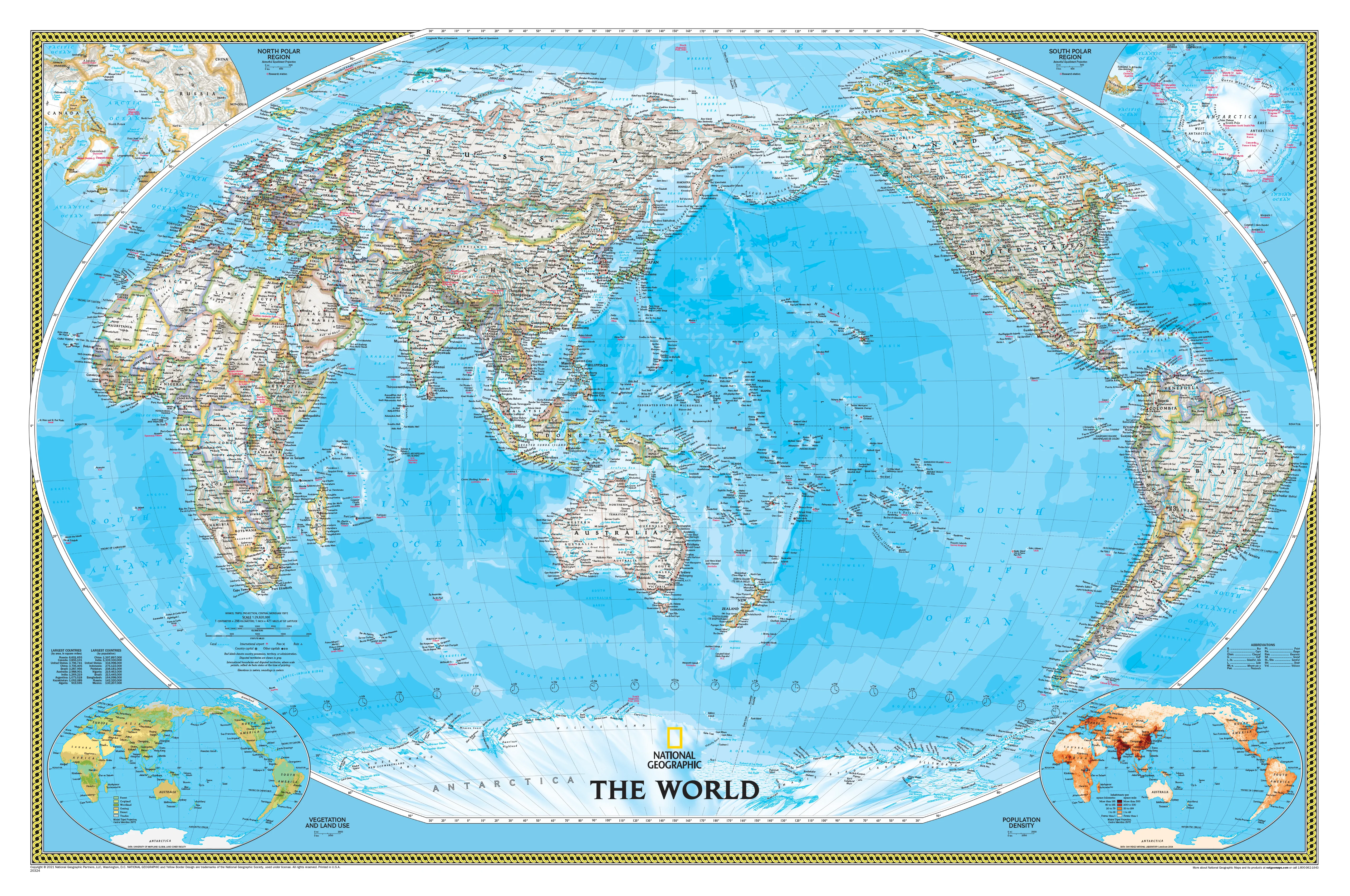
Reframe your global perspective with this Africa-Centred World Political Wall Map by National Geographic—a breathtakingly detailed, large-format wall map that blends stunning cartographic clarity with timeless design. With its balanced Winkel Tripel projection and elegantly neutral styling, this map invites exploration, education, and inspiration.
Perfect for classrooms, home offices, libraries, meeting rooms, and those with a passion for geography, this map is as informative as it is visually striking.
🌐 Why Africa-Centred?
Unlike the traditional Europe- or Pacific-centred maps, this version places Africa in the central view, offering:
-
A more balanced global layout, without geographic bias
-
Better visual understanding of global relationships
-
Ideal for international institutions, educators, and travellers seeking a broader world view
The Winkel Tripel projection ensures minimal distortion of land masses, providing an accurate and proportional representation of the planet.
🧭 Map Highlights
✔️ Clear, Updated Political Boundaries
-
Bold delineation of country borders
-
All nations shown in light neutral tones to enhance legibility of names
-
Major cities, capitals, disputed territories, and geographic regions clearly marked
⛰️ Physical & Oceanographic Features
-
Mountain ranges represented with shaded relief for realistic terrain depth
-
Ocean currents and bathymetric contours reveal undersea features such as trenches and ridges
-
More ocean detail than standard political maps
📊 Inset Thematic Maps
Includes small but powerful reference layers in the lower corners showing:
-
Population Density
-
Land Use Patterns
-
Vegetation Zones
🖨️ Printing & Format Options
Crafted with exceptional materials for a variety of uses and aesthetics:
| Finish | Description |
|---|---|
| 📜 Paper (160 gsm) | Premium matte stock – perfect for framing behind glass |
| 💧 Laminated | Fully encapsulated in two 80-micron gloss laminate sheets – durable, wipe-clean |
| 🖼️ Canvas (395 gsm) | Printed on archival HP Matte Canvas with pigment inks – fade-resistant, textured |
🪵 Optional Hanging System
Enhance presentation with natural timber hang rails, available for both laminated and canvas versions:
-
Top and bottom battens with a discreet hanging cord
-
No framing required – simply hang on a single wall hook or nail
-
Finished in a clear lacquer to match classic or contemporary décor
🕒 Please allow up to 10 working days for dispatch when selecting hang-railed formats, as each set is custom assembled by our professional framer.
📐 Specifications
| Feature | Detail |
|---|---|
| Map Title | World Political – Africa Centred |
| Publisher | National Geographic Society |
| Projection | Winkel Tripel |
| Scale | 1:22,445,000 |
| Dimensions | 1759 mm (W) × 1219 mm (H) |
| Edition | 2018 |
| Language | English |
| Printed In | Australia |
🎯 Ideal For
| Audience | Use Case |
|---|---|
| 🎓 Educators | Bring global geography into the classroom with clarity and balance |
| 🏢 Professionals | Enhance boardrooms, lobbies, or executive offices |
| 🌍 Travellers | Visualise journeys and track world travels |
| 📚 Collectors | A refined piece for any map collection |
| 🏡 Homeowners | A stunning centrepiece for living rooms, studies, or libraries |
📦 Shipping & Delivery
-
Paper and laminated versions shipped rolled in protective mailing tubes
-
Canvas and hang-railed options shipped flat or in reinforced tubes
-
Made and shipped from Australia
🗓️ Hang-railed options require up to 10 business days for custom assembly
🌎 See the World Differently
The Africa-Centred World Political Wall Map by National Geographic is not just a decorative feature—it's a global perspective reimagined. Whether you’re teaching, travelling, or simply curious about the world, this map blends antique elegance with geographic authority.
👉 Order now and bring the world into your space—in style, with clarity, and centred around a truly global view.
Original: $179.95
-70%$179.95
$53.98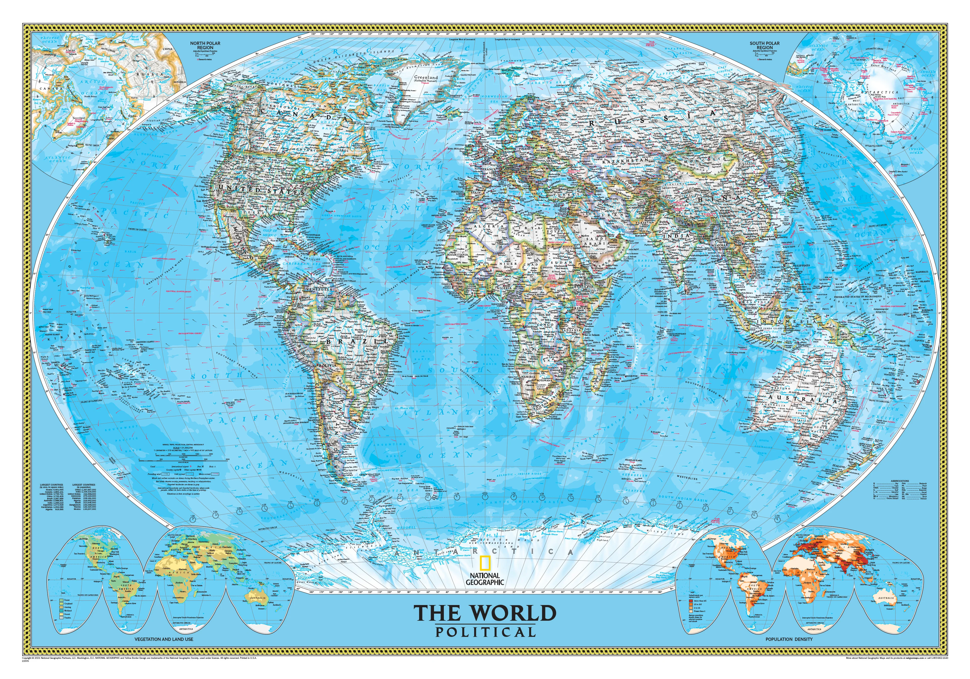
Description
By National Geographic
Elegant • Educational • Africa-Focused Perspective
🗺️ A Masterpiece of Political Geography – with Africa at the Heart
Reframe your global perspective with this Africa-Centred World Political Wall Map by National Geographic—a breathtakingly detailed, large-format wall map that blends stunning cartographic clarity with timeless design. With its balanced Winkel Tripel projection and elegantly neutral styling, this map invites exploration, education, and inspiration.
Perfect for classrooms, home offices, libraries, meeting rooms, and those with a passion for geography, this map is as informative as it is visually striking.
🌐 Why Africa-Centred?
Unlike the traditional Europe- or Pacific-centred maps, this version places Africa in the central view, offering:
-
A more balanced global layout, without geographic bias
-
Better visual understanding of global relationships
-
Ideal for international institutions, educators, and travellers seeking a broader world view
The Winkel Tripel projection ensures minimal distortion of land masses, providing an accurate and proportional representation of the planet.
🧭 Map Highlights
✔️ Clear, Updated Political Boundaries
-
Bold delineation of country borders
-
All nations shown in light neutral tones to enhance legibility of names
-
Major cities, capitals, disputed territories, and geographic regions clearly marked
⛰️ Physical & Oceanographic Features
-
Mountain ranges represented with shaded relief for realistic terrain depth
-
Ocean currents and bathymetric contours reveal undersea features such as trenches and ridges
-
More ocean detail than standard political maps
📊 Inset Thematic Maps
Includes small but powerful reference layers in the lower corners showing:
-
Population Density
-
Land Use Patterns
-
Vegetation Zones
🖨️ Printing & Format Options
Crafted with exceptional materials for a variety of uses and aesthetics:
| Finish | Description |
|---|---|
| 📜 Paper (160 gsm) | Premium matte stock – perfect for framing behind glass |
| 💧 Laminated | Fully encapsulated in two 80-micron gloss laminate sheets – durable, wipe-clean |
| 🖼️ Canvas (395 gsm) | Printed on archival HP Matte Canvas with pigment inks – fade-resistant, textured |
🪵 Optional Hanging System
Enhance presentation with natural timber hang rails, available for both laminated and canvas versions:
-
Top and bottom battens with a discreet hanging cord
-
No framing required – simply hang on a single wall hook or nail
-
Finished in a clear lacquer to match classic or contemporary décor
🕒 Please allow up to 10 working days for dispatch when selecting hang-railed formats, as each set is custom assembled by our professional framer.
📐 Specifications
| Feature | Detail |
|---|---|
| Map Title | World Political – Africa Centred |
| Publisher | National Geographic Society |
| Projection | Winkel Tripel |
| Scale | 1:22,445,000 |
| Dimensions | 1759 mm (W) × 1219 mm (H) |
| Edition | 2018 |
| Language | English |
| Printed In | Australia |
🎯 Ideal For
| Audience | Use Case |
|---|---|
| 🎓 Educators | Bring global geography into the classroom with clarity and balance |
| 🏢 Professionals | Enhance boardrooms, lobbies, or executive offices |
| 🌍 Travellers | Visualise journeys and track world travels |
| 📚 Collectors | A refined piece for any map collection |
| 🏡 Homeowners | A stunning centrepiece for living rooms, studies, or libraries |
📦 Shipping & Delivery
-
Paper and laminated versions shipped rolled in protective mailing tubes
-
Canvas and hang-railed options shipped flat or in reinforced tubes
-
Made and shipped from Australia
🗓️ Hang-railed options require up to 10 business days for custom assembly
🌎 See the World Differently
The Africa-Centred World Political Wall Map by National Geographic is not just a decorative feature—it's a global perspective reimagined. Whether you’re teaching, travelling, or simply curious about the world, this map blends antique elegance with geographic authority.
👉 Order now and bring the world into your space—in style, with clarity, and centred around a truly global view.